Industrial and commercial drone applications
Agriculture and field monitoring
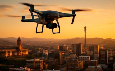
Across South Africa’s vast industrial landscapes, these tools have become essential. We watch them roam the skies above mines, ports, and construction sites, turning raw data into decision-ready insight. Industrial and commercial drone applications span asset inspection, hazard monitoring, and rapid site surveys. In practice, drones can be used for rapid site surveys, asset management, and emergency response.
On the farm, fields speak in colors and contours, and drones help translate that language into action!
- Crop health mapping, soil moisture assessment, and irrigation optimization
- Pest detection and early warning systems
- Livestock counting and fence-line checks
These aerial allies weave data into the tempo of harvests, making every hectare a page in a living ledger.
Construction site surveying and progress tracking
Across South Africa’s bustling construction belts, drones can be used for unlocking time and precision—the kind that turns raw data into decisive action. On active sites, crews report faster inspections and fewer rework cycles as flight data translates into clear, actionable plans. The sky becomes a new kind of supervisor, quietly boosting safety and efficiency.
Construction site surveying and progress tracking hinge on precise, repeatable data from routine flights. Sweep flights update site maps, while 3D models reveal stage-by-stage progress, keeping the workflow in sync with BIM.
- Orthomosaic site maps
- 3D models for progress comparisons
- Volume calculations for earthworks
In addition, real-time hazard monitoring and emergency response capabilities empower teams to respond before risk escalates, turning a potential delay into a controlled outcome. The result is a narrative of construction that moves with the speed of the skyline, without sacrificing oversight.
Public safety and emergency response
In South Africa’s crowded urban landscapes, every minute matters during emergencies. Recent trials indicate that drone reconnaissance can trim initial assessment times by up to 40%, turning uncertainty into actionable intelligence before responders reach the scene. I’ve watched teams transform chaos into calculated decisions from a skybound vantage, where distance becomes clarity!
In industrial and commercial settings, drones can be used for rapid site assessment, perimeter monitoring, and real-time hazard detection, strengthening safety protocols.
- perimeter and critical asset surveillance
- rapid triage of incident zones
- infrastructure health checks for ongoing operations
As the line between human judgment and machine insight thickens, we must balance ambition with accountability, ensuring privacy and oversight accompany every flight.
Infrastructure inspection and utilities management
Powering ahead through South Africa’s bustling industrial zones, I know a single drone flight can tilt the odds in our favour. In trials across municipal and private networks, drone-assisted surveys have slashed inspection times by as much as 40%, turning uncertainty into actionable insight before crews arrive.
Industrial and commercial settings demand rapid, repeatable checks—and I see how drones can be used for infrastructure inspection and utilities management, from substations and wind farms to water utilities and telecom corridors.
- Structural health monitoring of bridges, towers, and pipelines
- Real-time asset condition checks and remote diagnostics
- Thermal imaging and sensor data to detect energy losses, leaks, and corrosion
Yet ambition must walk a line with oversight; every flight in SA carries privacy considerations and governance that keeps the gaze honest.
Creative and media uses for drones
Aerial photography and videography for campaigns
Across the South African media landscape, campaigns that rise above the ordinary capture audiences 40% more quickly. In campaigns, drones can be used for sweeping dawn shots that drape vineyards and coastlines in gold, and for intimate product close-ups captured from a whispering sky. The effect is storytelling that feels ancient and new at once, a bridge between field and forest, boulder and billboard.
From these elevated vantage points, a few creative avenues emerge that sing with motion and mood:
- cinematic aerials that tell brand stories with scale
- live event coverage and behind‑the‑scenes moments
- dynamic product reveals and immersive 360° tours
There’s a practical poetry here—planning, pacing, light, and shadow aligning like stars—so campaigns land with clarity, character, and a dash of awe that lingers in the memory.
Event coverage and live broadcasting
Campaigns that rise above the ordinary capture audiences 40% faster across South Africa’s media landscape, where every frame matters. drones can be used for live event coverage that feels intimate yet expansive, and for broadcasting backstage moments with a rhythm that humanises the spectacle—the sky acting as a silent stage manager coaxing drama from light.
At events, the drone’s eye can thread through crowds and light rigs, providing assets that pair with social highlights and prime-time cuts. Consider these avenues:
- Glimpses of the crowd and ambiance from above, adding texture to a storyline.
- Seamless feeds that slot into broadcasts without crowd noise or restrictions.
- Overhead captures of performances and brand moments that scale the narrative.
Film, television, and music video production
In South Africa’s vibrant film landscape, aerial shots redefine pacing and scale. Audiences retain up to 25% longer when drone-driven moments punctuate a showreel. drones can be used for weaving kinetic sequences that feel intimate yet expansive, turning a studio session into a skyward meditation.
For film, television, and music videos, the drone becomes a silent co-director. It glides past light rigs, choreographed moves, and candid reactions, delivering texture that ground shots alone cannot capture.
- Establishing mood with sweeping skylines
- Fluid transitions between scenes
- Backstage access and rehearsal energy
From Cape Town’s coastlines to Gauteng’s skylines, such imagery travels beyond the screen into social cuts and promo reels, imparting a kinetic signature to SA productions that feels both intimate and expansive.
Travel and hospitality promotions with drone footage
South Africa’s travel brands are discovering that aerial storytelling sells experiences before guests click ‘book.’ Engagement on hotel promos shot from above climbs when views reveal sunlit verandas, dramatic coastlines, and glittering pools. drones can be used for travel and hospitality promotions by weaving exterior grandeur with intimate moments—lobby reflections, dawn rituals in courtyards, and horizon lines that linger.
From Cape Town’s coastlines to winelands and game reserves, the drone’s eye turns stays into cinematic invitations that travel far beyond a lobby wall.
- Coastal resorts and city hotels with sweeping shorelines and rooftop vistas
- Wine country lodges framed against wildlife and golden light
- Promotional promos and social cuts that highlight guest experiences and unobtrusive service
These visuals forge a kinetic identity for SA hospitality—intimate in detail, expansive in scope, and ready for every screen that greets South Africa’s travelers.
Technical capabilities and safety considerations
Flight planning and autonomous missions
Technical capability shapes what the drone fleet can deliver on site. High-resolution sensors, RTK positioning, and real-time data streams let teams map, inspect, and monitor with speed and accuracy. Safety considerations—redundant power, fail-safe landings, encrypted links—are built into every mission. In many roles, drones can be used for precise, data-rich work that saves time and reduces risk!
Flight planning and autonomous missions demand disciplined design and clear boundaries. In South Africa, comply with airspace rules and local geofences, and choose mission profiles that suit the environment. The aim is reliable autonomy that respects privacy and protects people and property.
- Redundant power and failsafes
- Geofencing and secure data handling
- Clear privacy and regulatory alignment
That balance of capability and caution keeps campaigns efficient and credible, whether on a city rooftop or a remote valley.
Stabilization and sensors for image quality
In the dawn over South Africa’s cities, data becomes a conversation between wind and wire. Stabilization and sensors for image quality turn jitter into clarity, letting feeds ride the breeze with grace. When the gimbal and sensor fusion work in harmony, drones can be used for precise, data-rich visuals that translate into reliable field decisions.
Key enablers include:
- Stabilized gimbals counter rotor jitter for smooth, steady framing
- High-resolution sensors with HDR or global shutter for faithful detail
- Real-time sensor fusion and anti-vibration systems that preserve edges in motion
In every mission, technical excellence and safety ride side by side, turning wind into legible data across varied terrains.
Power management and battery optimization
Power is the quiet engine behind every horizon you chase with a drone. In South Africa’s varied landscapes, technical capability and safety nuance matter as much as hardware. Drones can be used for precise data capture and safe operation, but only when power management keeps pace with ambition.
Smart batteries, thermal safeguards, and efficient flight planning merge to extend flight time without sacrificing performance. Real-time telemetry helps throttle motors, adjust speeds, and conserve energy when gliding across open fields or navigating a coastal canyon. Batteries deployed in extreme heat or cold demand careful charge discipline and storage practices to preserve life cycles.
Power management essentials:
- Advanced battery management systems monitor charge, temperature, and health in real time.
- Optimized payload and flight parameters to maximize endurance on mission day.
- Smart charging and storage routines to protect long-term capacity.
Safety considerations, from preflight checks to automatic return-to-home, sit next to power strategy as a practical discipline—because when the wind turns, reliable power is the difference between data and drift.
Regulatory compliance and safety practices
Across South Africa’s dramatic terrain, tech specs matter as much as courage. High-resolution sensors, stabilized gimbals, RTK/PPK positioning, and smart flight planning expand what can be done in hard-to-reach places. These capabilities show what drones can be used for: precise topographic maps, thermal surveys, and rapid site reconnaissance.
Safety and regulatory compliance go hand in hand. Preflight risk checks, site surveys, and clearances with the relevant aviation authority keep operations lawful and predictable. Real-time telemetry and obstacle avoidance reduce risk; automatic return-to-home is a non-negotiable safeguard.
- Preflight checks and risk assessment
- Airspace permissions and operator licensing considerations
- Data privacy, retention, and usage compliance
- Ongoing maintenance and fault logging
Data privacy and airspace awareness
Across South Africa’s vast, changing skies, every mission hinges on precision and purpose. ‘drones can be used for’ turning raw terrain into reliable intelligence—fast, traceable, and defendable.
Data privacy and airspace awareness aren’t afterthoughts; they are the backbone of responsible flight.
- Data governance: encryption, access controls, retention, and usage policies aligned with POPIA.
- Airspace awareness: real-time telemetry, NOTAMs, geofencing, and SACAA licensing expectations.
- Operational privacy: minimising image capture in sensitive zones and secure data handling.
These guardrails shape every deployment, keeping operations lawful and the sky cooperative.
Emerging trends and future potential of drones
Artificial intelligence and autonomous decision making
Drones are stepping from tools into decision-makers! A recent industry snapshot indicates AI-enabled drones cut routine tasks by up to 40%, turning data into decisions in seconds. In South Africa’s fast-growing sectors—from mining to media—this shift is turning flight into foresight.
Artificial intelligence and autonomous decision-making are reshaping how drones operate: on-board edge processing, robust machine-vision, and trustworthy autonomy. When AI shines, drones can be used for real-time hazard detection, dynamic routing, and immediate incident response—empowering teams to act before conditions worsen.
- Real-time hazard detection and mitigation
- Adaptive routing and autonomous mission updates
- Collaborative drone swarms for large-area coverage
The frontier is personalizable, resilient, and increasingly accessible, with pilots and planners sharing a common language of trust and data.
Drone swarms and coordinated missions
Across South Africa’s varied terrains, the horizon is bright with swarm-powered possibility. A recent study shows that drone swarms can cut survey times by up to 60% in rugged landscapes. The frontier reveals how drones can be used for expansive surveys, real-time hazard mapping, and coordinated reconnaissance across vast landscapes—outpacing human teams and enabling decisions at the speed of data.
Drone swarms and coordinated missions are moving from novelty to necessity. Edge processing and AI choreograph dozens of units, delivering synchronized imagery, fault-tolerant networks, and adaptive tasking as conditions evolve.
- Massive-area mapping with resilience
- Collaborative sensing for live incident response
- Dynamic mission re-planning and safe autonomy
Together, these trends craft a future where flight is foresight, where teams in Cape Town to the Highveld share a language of trust and data.
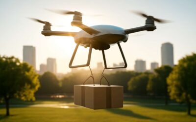
Urban air mobility and package delivery ecosystems
Skyways are no longer fantasies but a working grammar of tomorrow. In South Africa’s cities, urban air mobility is sketching a new layer of commerce, where agile cargo flows align with streets below and data above. The horizon holds more than speed: resilience, real-time hazard awareness, and the ability to connect remote regions with urban hubs. Cape Town’s coastline and the Highveld’s plains become nodes in a wider network, as silent electric craft and intelligent routes optimize what used to take hours.
As the landscape shifts, drones can be used for urban mobility pilots, secure last-mile delivery, and emergency logistics, weaving a package-delivery ecosystem that reduces road congestion and speeds service across South Africa’s terrain. Regulatory clarity, community engagement, and power-sipping batteries will shape the cadence of flight, ensuring that the promise of the air becomes a thread in life—not a spectacle but a working partnership between tech and people.
Data analytics, mapping, and environmental monitoring innovations
“Drones turn raw data into decisions in minutes!” says a leading South African analyst. Early pilots show data turnaround halved as aerial sensors scan coastlines, rivers, and farmlands in real time. Drones can be used for rapid environmental assessment, mapping, and monitoring—speaking a language the ground forgets too quickly.
Analytics from drone streams fuse weather, topography, and biodiversity into actionable insight. Coastal erosion, water quality, and urban green cover become trackable metrics rather than snapshots. Environmental monitoring innovations—thermal sensing, hyperspectral data, and long-endurance flights—pull remote stories into the present, guiding policy and business decisions.
- Real-time coastal and flood mapping
- Hyperspectral and thermal environmental surveys
- Wildlife and habitat monitoring at scale
South Africa benefits from this data-rich edge, where drones become not just cameras in the sky but tools for responsible stewardship and resilient planning.
Sustainability and efficiency improvements in aerial operations
Across South Africa’s skies, drone programs are turning risk into real-time understanding. A coastal trial near Cape Town slashed data turnaround from hours to minutes. This is where drones can be used for accelerating sustainable planning—shaping how we protect coastlines, farms, and urban spaces with a lighter footprint.
Emerging trends are taking root, hinting at a future where aerial work is leaner and smarter:
- Longer endurance through advanced powertrains and lightweight materials that stretch every flight.
- Modular payloads that swap in thermal, multispectral, or LiDAR sensors in minutes for rapid re-tasking.
- Networked operations and edge-to-cloud data fusion that speed up field-to-policy decisions.
With this momentum, the future promises more resilient, efficient aerial operations that harmonize innovation with stewardship across SA.

0 Comments